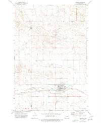
1973 Map of Hebron
USGS Topo · Published 1977About this map
The city of Hebron serves as the focal point of this 1970s survey, situated where the Burlington Northern railroad corridor meets the winding path of the Knife River. The town's layout reflects a classic Midwestern rail-centered economy, featuring prominent storage bins near the tracks and essential community institutions like the High School and the St. John and St. Ann cemeteries. This era of the landscape is marked by the active extraction of local resources, evidenced by several gravel pits and a mine located north of the city center. The surrounding terrain is defined by the convergence of county lines, where Mercer, Morton, and Stark counties meet. The map captures the interplay between the natural drainage of the Knife River and the engineered infrastructure required for a mid-century agricultural and transit hub.
Find a feature on this map
15 named features on this map. Tap any name to fly to it.
Don’t see what you’re looking for? This feature index may not catch every label — zoom into the map to look around manually.
Map Details
Editions of this 1973 Hebron Map
This is the sole edition of this map. No revisions or reprints were ever made.
Other maps of this area

1953 · Dickinson
USGS Topo · 1:250,000

1953 · Watford City
USGS Topo · 1:250,000

1954 · Bismarck
USGS Topo · 1:250,000

1954 · McClusky
USGS Topo · 1:250,000

1957 · Dickinson
USGS Topo · 1:250,000

1957 · Watford City
USGS Topo · 1:250,000

1958 · Bismarck
USGS Topo · 1:250,000

1958 · McClusky
USGS Topo · 1:250,000

1967 · Watford City
USGS Topo · 1:250,000
1970 · Glen Ullin NW
USGS Topo · 1:24,000