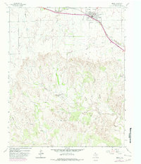
1963 Map of Hedley
USGS Topo · Published 1982About this map
Hedley serves as the focal point for this survey of the Texas Panhandle, positioned along the northern plains where the landscape begins to fracture into the drainage basins of the southeast. The town's layout and its elevation bench mark are recorded alongside the natural hydrology that defines the local ranching environment. Drainage patterns such as Oklahoma Draw and Killfoil Draw cut through the high ground, while Hatton Creek marks the lower, more broken terrain to the south. The mapping of these features reflects the area’s reliance on intermittent water sources and natural topography for land management in Donley County during the early 1960s. This edition includes specialized data on local fence lines and woodland cover, offering a precise look at the rural spatial organization and vegetation during this period.
Find a feature on this map
4 named features on this map. Tap any name to fly to it.
Don’t see what you’re looking for? This feature index may not catch every label — zoom into the map to look around manually.
Map Details
Editions of this 1963 Hedley Map
2 editions found
Other maps of this area

1954 · Plainview
USGS Topo · 1:250,000

1958 · Plainview
USGS Topo · 1:250,000

1959 · Lelia Lake Creek
USGS Topo · 1:24,000

1959 · McKnight
USGS Topo · 1:24,000

1960 · Brice
USGS Topo · 1:62,500

1961 · Memphis
USGS Topo · 1:62,500

1962 · Lelia Lake
USGS Topo · 1:24,000

1963 · Hedley
USGS Topo · 1:24,000

1963 · Clarendon SE
USGS Topo · 1:24,000

1963 · Giles
USGS Topo · 1:24,000