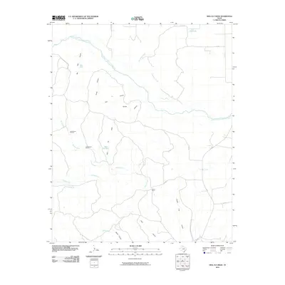
2010 Map of Heel Fly Draw
USGS Topo · Published 2010About this map
Oxbow Ranch anchors the southeastern landscape of this Hall County region, where the winding drainage systems define the local geography. The area is dominated by the broad, braided course of the Prairie Dog Town Fork Red River to the north and the Little Red River to the south. This network of canyons and draws, including Heel Fly Draw, Dad Canyon, and Mullin Canyon, illustrates a land deeply shaped by seasonal water flow and ranching infrastructure. Vital water sources like Big Tank, Heel Fly Tank, and Deep Lake are scattered throughout the territory, supported by landmarks such as the Upper Wildcat Windmill and Lower Wildcat Windmill. These features suggest a specialized reliance on traditional water-management techniques in a terrain where surface water is periodic and essential for livestock and land use.
Find a feature on this map
28 named features on this map. Tap any name to fly to it.
Don’t see what you’re looking for? This feature index may not catch every label — zoom into the map to look around manually.
Map Details
Editions of this 2010 Heel Fly Draw Map
This is the sole edition of this map. No revisions or reprints were ever made.
Other maps of this area

1954 · Plainview
USGS Topo · 1:250,000

1958 · Plainview
USGS Topo · 1:250,000

1960 · Brice
USGS Topo · 1:62,500

1961 · Memphis
USGS Topo · 1:62,500

1967 · Tampico Siding
USGS Topo · 1:24,000

1967 · Turkey
USGS Topo · 1:24,000

1967 · Blue Tank Canyon
USGS Topo · 1:24,000

1976 · Brice SE
USGS Topo · 1:24,000

1976 · Brice NW
USGS Topo · 1:24,000

1976 · Memphis NW
USGS Topo · 1:24,000