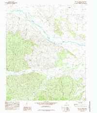
1985 Map of Heel Fly Draw
USGS Topo · Published 1985About this map
The Prairie Dog Town Fork Red River dominates this portion of Hall County, cutting a wide, sandy path through the high plains. The landscape is defined by an intricate network of erosional features, most notably Heel Fly Draw and several deeply incised canyons such as Big Tank Canyon, Jones Canyon, and Dad Canyon. This mid-1980s topography reveals a remote ranching and resource-extraction environment where water management is critical, as evidenced by the distribution of numerous wells and cattle-watering sites like Heel Fly Tank and Panther Tank.
Find a feature on this map
17 named features on this map. Tap any name to fly to it.
Don’t see what you’re looking for? This feature index may not catch every label — zoom into the map to look around manually.
Map Details
Editions of this 1985 Heel Fly Draw Map
This is the sole edition of this map. No revisions or reprints were ever made.
Other maps of this area

1954 · Plainview
USGS Topo · 1:250,000

1958 · Plainview
USGS Topo · 1:250,000

1960 · Brice
USGS Topo · 1:62,500

1961 · Memphis
USGS Topo · 1:62,500

1967 · Tampico Siding
USGS Topo · 1:24,000

1967 · Turkey
USGS Topo · 1:24,000

1967 · Blue Tank Canyon
USGS Topo · 1:24,000

1976 · Brice SE
USGS Topo · 1:24,000

1976 · Brice NW
USGS Topo · 1:24,000

1976 · Memphis NW
USGS Topo · 1:24,000