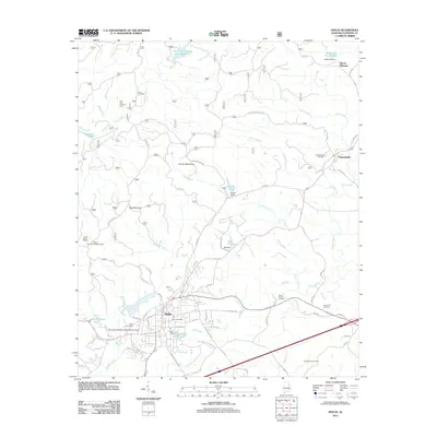
2011 Map of Heflin
USGS Topo · Published 2011About this map
Heflin serves as the central hub in this modern topographic study, showing a developed street grid including McAlpin Dr and Evans Bridge Rd near the banks of Town Creek. The landscape transition from the town center to the surrounding ridges is marked by prominent landmarks like Flag Mountain and Brymer Mountain, with several water management features such as Heflin Dam and the Cahulga Creek Watershed Dam Number 1 shaping the local hydrology.
Find a feature on this map
74 named features on this map. Tap any name to fly to it.
Don’t see what you’re looking for? This feature index may not catch every label — zoom into the map to look around manually.
Map Details
Editions of this 2011 Heflin Map
This is the sole edition of this map. No revisions or reprints were ever made.
Other maps of this area

1889 · Tallapoosa
USGS Topo · 1:125,000

1892 · Tallapoosa
USGS Topo · 1:125,000

1897 · Tallapoosa
USGS Topo · 1:125,000

1900 · Anniston
USGS Topo · 1:125,000

1953 · Atlanta
USGS Topo · 1:250,000

1954 · Choccolocco
USGS Topo · 1:24,000

1957 · Atlanta
USGS Topo · 1:250,000

1958 · Atlanta
USGS Topo · 1:250,000
1966 · Hightower
USGS Topo · 1:24,000
1966 · Oak Level
USGS Topo · 1:24,000