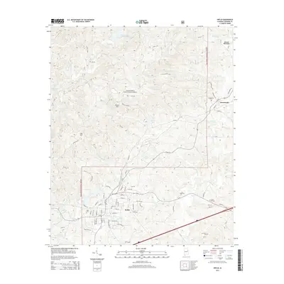
2014 Map of Heflin
USGS Topo · Published 2014About this map
Heflin and Edwardsville anchor this 2014 survey of Cleburne County, showing the intersection of heavy transit and protected wilderness. The Norfolk Southern rail line and US Hwy 78 cut through the heart of the region, providing the primary east-west corridors for the town of Heflin. A large portion of the landscape is dominated by the Talladega National Forest, where high points like Brymer Mtn and Flag Mtn overlook numerous small drainages and impoundments, including Lake Heflin and Thomas Lake. For family historians, the map is remarkably detailed regarding burial sites, preserving the locations of Cole Cem, Happy Hill Cem, and Old Liberty Cem, among several others. This record of the mid-2010s documents how the local road network, including the Old Jacksonville Hwy, navigates the complex terrain between the forest and the Cane Creek valley.
Find a feature on this map
88 named features on this map. Tap any name to fly to it.
Don’t see what you’re looking for? This feature index may not catch every label — zoom into the map to look around manually.
Map Details
Editions of this 2014 Heflin Map
This is the sole edition of this map. No revisions or reprints were ever made.
Other maps of this area

1889 · Tallapoosa
USGS Topo · 1:125,000

1892 · Tallapoosa
USGS Topo · 1:125,000

1897 · Tallapoosa
USGS Topo · 1:125,000

1900 · Anniston
USGS Topo · 1:125,000

1953 · Atlanta
USGS Topo · 1:250,000

1954 · Choccolocco
USGS Topo · 1:24,000

1957 · Atlanta
USGS Topo · 1:250,000

1958 · Atlanta
USGS Topo · 1:250,000
1966 · Hightower
USGS Topo · 1:24,000
1966 · Oak Level
USGS Topo · 1:24,000