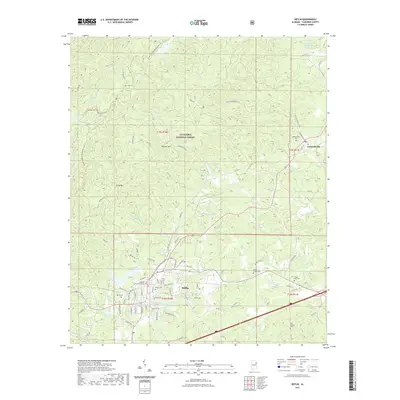
2021 Map of Heflin
USGS Topo · Published 2021About this map
Heflin serves as the focal point of this 2021 study, anchored by the Cleburne County Courthouse and a surrounding network of local roads that lead into the rugged hills of the Talladega National Forest. The landscape is defined by the ridge-and-valley topography of the southern Appalachians, featuring landmarks like Brymer Mtn and Flag Mtn. To the east, the community of Edwardsville sits near the headwaters of Cane Cr, reflecting the long-established settlement patterns of eastern Alabama. For those tracing family roots, the map is remarkably detailed with burial sites, including Heflin Cem, Evans Chapel Cem, and Happy Hill Cem. Water resources are abundant, ranging from the recreational waters of Lake Heflin and Highrock Lake to the meandering courses of Shoal Cr and Cahulga Cr. The presence of the Pinhoti National Recreation Trail winding through the northern ridges highlights the area's modern role as a hub for outdoor activity amidst its traditional rural setting.
Find a feature on this map
91 named features on this map. Tap any name to fly to it.
Don’t see what you’re looking for? This feature index may not catch every label — zoom into the map to look around manually.
Map Details
Editions of this 2021 Heflin Map
This is the sole edition of this map. No revisions or reprints were ever made.
Other maps of this area

1889 · Tallapoosa
USGS Topo · 1:125,000

1892 · Tallapoosa
USGS Topo · 1:125,000

1897 · Tallapoosa
USGS Topo · 1:125,000

1900 · Anniston
USGS Topo · 1:125,000

1953 · Atlanta
USGS Topo · 1:250,000

1954 · Choccolocco
USGS Topo · 1:24,000

1957 · Atlanta
USGS Topo · 1:250,000

1958 · Atlanta
USGS Topo · 1:250,000
1966 · Hightower
USGS Topo · 1:24,000
1966 · Oak Level
USGS Topo · 1:24,000