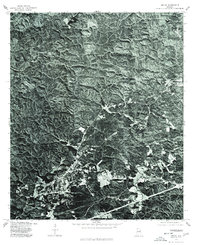
1975 Map of Heflin
USGS Topo · Published 1977About this map
Cleburne County terrain is captured here through a 1975 orthophotograph, providing a detailed visual record of the land surface before significant modern development. The imagery emphasizes the complex ridge-and-valley topography characteristic of this part of Alabama, where wooded slopes and cleared bottomlands define the local geography. In the eastern portion of the sheet, the settlement of Edwardsville is clearly visible, showing the cluster of buildings and road intersections that formed the community's core at the time. This specific type of survey, produced in cooperation with the Soil Conservation Service, uses photographic data to reveal land use patterns, from timbered highlands to small agricultural clearings that might be missed on a traditional line-drawn topographic map.
Find a feature on this map
1 named feature on this map. Tap any name to fly to it.
Don’t see what you’re looking for? This feature index may not catch every label — zoom into the map to look around manually.
Map Details
Editions of this 1975 Heflin Map
This is the sole edition of this map. No revisions or reprints were ever made.
Other maps of this area

1889 · Tallapoosa
USGS Topo · 1:125,000

1892 · Tallapoosa
USGS Topo · 1:125,000

1897 · Tallapoosa
USGS Topo · 1:125,000

1900 · Anniston
USGS Topo · 1:125,000

1953 · Atlanta
USGS Topo · 1:250,000

1954 · Choccolocco
USGS Topo · 1:24,000

1957 · Atlanta
USGS Topo · 1:250,000

1958 · Atlanta
USGS Topo · 1:250,000
1966 · Hightower
USGS Topo · 1:24,000
1966 · Oak Level
USGS Topo · 1:24,000