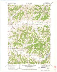
1969 Map of Hegg
USGS Topo · Published 1971About this map
The ridge-and-valley topography of Trempealeau and Jackson Counties defines this 1960s survey, where the settlement of Hegg sits at the confluence of the North Fork Beaver Creek and several narrow coulees. This rural landscape is heavily marked by its Norwegian-American heritage, evidenced by the numerous coulees named for local families including Salzwedel Coulee, Borreson Coulee, and Simonson Coulee. These deep, branching valleys dictate the winding path of Bradley Road and other rural routes that connect isolated farmsteads to spiritual hubs like Faith Ch and North Beaver Creek Ch. To the south, the terrain is anchored by the prominent Thimble Peak, while small-scale industry is visible in the scattered Quarries and a Sandpit near Franklin. The map captures a moment when traditional crossroads like Beachs Corners and Buckholz Corners served as essential navigation points for the surrounding agricultural community.
Find a feature on this map
37 named features on this map. Tap any name to fly to it.
Don’t see what you’re looking for? This feature index may not catch every label — zoom into the map to look around manually.
Map Details
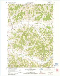
Editions of this 1969 Hegg Map
2 editions found
Other maps of this area

1926 · North Bend
USGS Topo · 1:62,500

1926 · Whitehall
USGS Topo · 1:62,500

1927 · Blair
USGS Topo · 1:62,500

1929 · Whitehall
USGS Topo · 1:62,500

1929 · Galesville
USGS Topo · 1:62,500

1929 · North Bend
USGS Topo · 1:62,500

1953 · Eau Claire
USGS Topo · 1:250,000

1958 · Eau Claire
USGS Topo · 1:250,000

1964 · Eau Claire
USGS Topo · 1:250,000
1968 · Blair
USGS Topo · 1:62,500