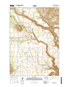
2017 Map of Hehe Butte
USGS Topo · Published 2017About this map
Hehe Butte rises as a prominent landmark in this portion of Wasco County, situated within a landscape defined by dramatic basalt plateaus and deeply carved watercourses. The drainage of the Warm Springs River dominates the southeastern quadrant, while Beaver Cr and its associated Beaver Creek Prairie mark the northern reaches. This 2017 survey illustrates a complex network of Bureau of Indian Affairs and forest roads, such as Simnasho Rd and Schoolie Rd, which connect high-elevation features like Simnasho Butte and Schoolie Flat. Significant geographic formations such as The Island and the expansive Mill Creek Flat highlight the importance of the river systems to the local topography. Evidence of water management is visible in the southwest, where the Mill Cr Canal skirts the edge of Miller Flat, demonstrating the engineered adjustments made to this high-desert environment.
Find a feature on this map
43 named features on this map. Tap any name to fly to it.
Don’t see what you’re looking for? This feature index may not catch every label — zoom into the map to look around manually.
Map Details
Editions of this 2017 Hehe Butte Map
This is the sole edition of this map. No revisions or reprints were ever made.
Other maps of this area

1924 · Mount Hood
USGS Topo · 1:125,000

1927 · Mount Hood
USGS Topo · 1:125,000

1927 · Mt. Jefferson
USGS Topo · 1:125,000

1928 · Madras
USGS Topo · 1:125,000

1930 · Mt. Jefferson
USGS Topo · 1:125,000

1930 · Dufur
USGS Topo · 1:125,000

1931 · Madras
USGS Topo · 1:125,000

1934 · Dufur
USGS Topo · 1:125,000

1953 · The Dalles
USGS Topo · 1:250,000

1955 · Bend
USGS Topo · 1:250,000