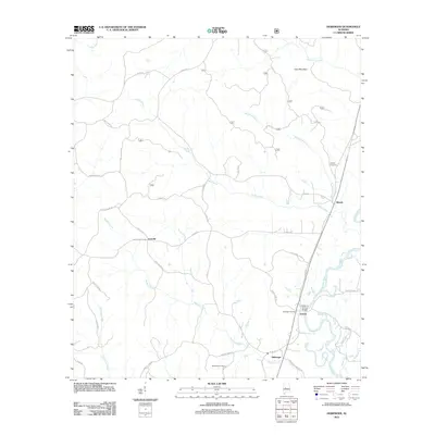
2011 Map of Heiberger
USGS Topo · Published 2011About this map
The Cahaba River winds through the eastern portion of this landscape, crossed by the Walter C Givhan Bridge near the settlement of Jericho. This area of Alabama is defined by its small rural communities and extensive network of named branches and creeks, including Wallace Creek and Taylor Creek, which drain the lowlands around Heiberger. Genealogical interest is found in the local burial grounds like Wooley Cemetery and Bethesda Cemetery, which are scattered among family-named roads such as Troy Perkins Rd and Cliff Osborn Rd. The northern terrain rises toward Cave Mountain, while the southern reaches feature the curious name of Potato Patch Creek. This record of the early 21st century documents the continued importance of river crossings and small crossroad settlements like Ironville and Ellards in maintaining the connectivity of this Perry County interior.
Find a feature on this map
39 named features on this map. Tap any name to fly to it.
Don’t see what you’re looking for? This feature index may not catch every label — zoom into the map to look around manually.
Map Details
Editions of this 2011 Heiberger Map
This is the sole edition of this map. No revisions or reprints were ever made.
Other maps of this area

1953 · Montgomery
USGS Topo · 1:250,000

1956 · Montgomery
USGS Topo · 1:250,000

1957 · Montgomery
USGS Topo · 1:250,000

1959 · Summerfield
USGS Topo · 1:62,500

1979 · Marion North
USGS Topo · 1:24,000

1979 · Morgan Springs
USGS Topo · 1:24,000

1979 · Harrisburg
USGS Topo · 1:24,000

1979 · Pondville
USGS Topo · 1:24,000

1980 · Payne Lake
USGS Topo · 1:24,000
1980 · Centreville West
USGS Topo · 1:24,000