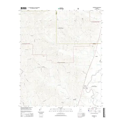
2014 Map of Heiberger
USGS Topo · Published 2014About this map
The Cahaba River winds through the southeastern portion of this landscape, crossed by the Walter C Givhan Bridge near the small settlement of Jericho. This area of Perry and Bibb counties is characterized by the dense woodlands of the Talladega National Forest, where topography rises toward Cave Mtn and falls into low-lying areas like Payne Bottom and Scott Btm. The road network connects rural communities such as Heiberger, Ironville, and Ellards, with many local routes named for area families, including Troy Perkins Rd and Alvin Carter Rd. Genealogists may find interest in the documented locations of the Bethesda Cem, Wooley Cem, and Heiberger Cem, which mark the historical footprint of these rural Alabama enclaves before further modernization of the forest and river corridor.
Find a feature on this map
52 named features on this map. Tap any name to fly to it.
Don’t see what you’re looking for? This feature index may not catch every label — zoom into the map to look around manually.
Map Details
Editions of this 2014 Heiberger Map
This is the sole edition of this map. No revisions or reprints were ever made.
Other maps of this area

1953 · Montgomery
USGS Topo · 1:250,000

1956 · Montgomery
USGS Topo · 1:250,000

1957 · Montgomery
USGS Topo · 1:250,000

1959 · Summerfield
USGS Topo · 1:62,500

1979 · Marion North
USGS Topo · 1:24,000

1979 · Morgan Springs
USGS Topo · 1:24,000

1979 · Harrisburg
USGS Topo · 1:24,000

1979 · Pondville
USGS Topo · 1:24,000

1980 · Payne Lake
USGS Topo · 1:24,000
1980 · Centreville West
USGS Topo · 1:24,000