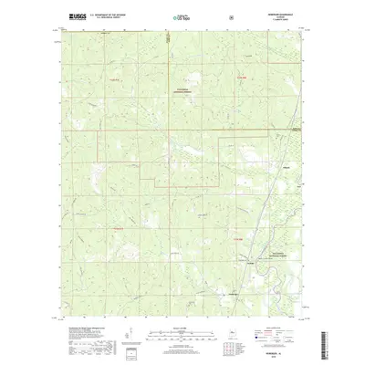
2018 Map of Heiberger
USGS Topo · Published 2018About this map
The Cahaba River winds through this section of the Talladega National Forest along the border of Perry and Bibb counties. This 2018 survey shows a rural landscape defined by forestry and small community centers, most notably at the junction of Jericho Rd and Upper River Rd. Here, the settlement of Jericho sits just north of Heiberger, where the Heiberger Cem and local roads like Alvin Carter Rd mark long-standing family footprints in the area. Further north, the Walter C Givhan Bridge provides a critical crossing over the river near Potato Patch Cr.
Find a feature on this map
52 named features on this map. Tap any name to fly to it.
Don’t see what you’re looking for? This feature index may not catch every label — zoom into the map to look around manually.
Map Details
Editions of this 2018 Heiberger Map
This is the sole edition of this map. No revisions or reprints were ever made.
Other maps of this area

1953 · Montgomery
USGS Topo · 1:250,000

1956 · Montgomery
USGS Topo · 1:250,000

1957 · Montgomery
USGS Topo · 1:250,000

1959 · Summerfield
USGS Topo · 1:62,500

1979 · Marion North
USGS Topo · 1:24,000

1979 · Morgan Springs
USGS Topo · 1:24,000

1979 · Harrisburg
USGS Topo · 1:24,000

1979 · Pondville
USGS Topo · 1:24,000

1980 · Payne Lake
USGS Topo · 1:24,000
1980 · Centreville West
USGS Topo · 1:24,000