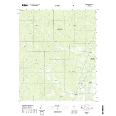
2021 Map of Heiberger
USGS Topo · Published 2021About this map
The Cahaba River winds through the southern portion of this landscape, crossed by the Walter C Givhan Bridge near the settlement of Jericho. This area of Perry County is defined by the heavy timber of the Talladega National Forest, which covers much of the northern and eastern sections. Small communities and family-named landmarks are scattered throughout the forest and bottomlands, including Heiberger and Ellards. Local history and genealogy are preserved in sites such as Bethesda Cem, Heiberger Cem, and Wooley Cem. The terrain rises toward the north to Cave Mtn, while the southwestern reaches are marked by Scott Bottom and Old Town Cr. This 2021 survey details a road network that reflects long-standing family and community connections, with names like Rolen Osborn, Troy Perkins Rd, and Sardis Church Rd defining the local geography.
Find a feature on this map
53 named features on this map. Tap any name to fly to it.
Don’t see what you’re looking for? This feature index may not catch every label — zoom into the map to look around manually.
Map Details
Editions of this 2021 Heiberger Map
This is the sole edition of this map. No revisions or reprints were ever made.
Other maps of this area

1953 · Montgomery
USGS Topo · 1:250,000

1956 · Montgomery
USGS Topo · 1:250,000

1957 · Montgomery
USGS Topo · 1:250,000

1959 · Summerfield
USGS Topo · 1:62,500

1979 · Marion North
USGS Topo · 1:24,000

1979 · Morgan Springs
USGS Topo · 1:24,000

1979 · Harrisburg
USGS Topo · 1:24,000

1979 · Pondville
USGS Topo · 1:24,000

1980 · Payne Lake
USGS Topo · 1:24,000
1980 · Centreville West
USGS Topo · 1:24,000