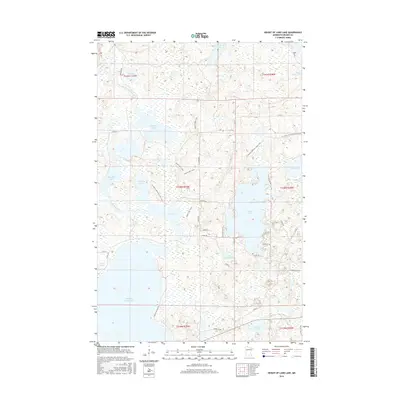
2016 Map of Height of Land Lake
USGS Topo · Published 2016About this map
Height of Land Lake dominates this glacial landscape in Becker County, where the Otter Tail River and Egg River thread through an intricate system of wetlands and small basins. The 2016 survey illustrates a region defined by its hydrography, featuring numerous named bodies of water including Rice Lake, Chippewa Lake, and Island Lake. Settlement patterns are concentrated along the lake fringes, indicated by local routes like W Island Dr and E Height of Land Dr, while the interior remains primarily undeveloped marsh and forest. Modern recreational corridors are well-established, notably the N Country National Scenic Trail and the local Booth Lake Trails, which provide access to the more isolated areas near Booth Lake. The map serves as a detailed record of the mid-2010s shoreline and the rural road network, including the specifically named Schoolhouse Rd, reflecting the area's ongoing identity as a lakeside community and wilderness destination.
Find a feature on this map
42 named features on this map. Tap any name to fly to it.
Don’t see what you’re looking for? This feature index may not catch every label — zoom into the map to look around manually.
Map Details
Editions of this 2016 Height of Land Lake Map
This is the sole edition of this map. No revisions or reprints were ever made.
Other maps of this area

1953 · Brainerd
USGS Topo · 1:250,000

1954 · Bemidji
USGS Topo · 1:250,000

1957 · Brainerd
USGS Topo · 1:250,000

1957 · Bemidji
USGS Topo · 1:250,000

1958 · Bemidji
USGS Topo · 1:250,000

1958 · Brainerd
USGS Topo · 1:250,000

1959 · Toad Mountain
USGS Topo · 1:24,000

1959 · Flat Lake
USGS Topo · 1:24,000

1959 · Rochert
USGS Topo · 1:24,000

1959 · Height Of Land Lake
USGS Topo · 1:24,000