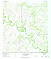
1960 Map of Helena
USGS Topo · Published 1961About this map
Helena sits as a quiet hub in Karnes County, positioned at the convergence of several major waterways and regional roads during the mid-twentieth century. The San Antonio River meanders sharply across the central landscape, joined by its tributaries including Cibolo Creek, Ecleto Creek, and Dry Ecleto Creek. This network of water determined the settlement's early importance and ongoing geography. The map reveals a land utilized for both agriculture and industry, with multiple Quarries and large industrial Pipelines crossing the terrain. Local history and genealogy are anchored by the Helena Cem and another smaller Cem located nearby, while the elevation of Lookout Hill provides a vantage point over the river valley. The dense collection of creeks like Mc Tunnel Creek highlights the drainage patterns that defined life and land use in this part of South Texas.
Find a feature on this map
12 named features on this map. Tap any name to fly to it.
Don’t see what you’re looking for? This feature index may not catch every label — zoom into the map to look around manually.
Map Details
Editions of this 1960 Helena Map
Other maps of this area

1920 · Smiley
USGS Topo · 1:125,000

1953 · Beeville
USGS Topo · 1:250,000

1953 · Seguin
USGS Topo · 1:250,000

1956 · Beeville
USGS Topo · 1:250,000

1956 · Karnes City
USGS Topo · 1:62,500

1958 · Seguin
USGS Topo · 1:250,000

1960 · Beeville
USGS Topo · 1:250,000
1960 · Karnes City
USGS Topo · 1:24,000

1960 · Kosciusko
USGS Topo · 1:24,000

1960 · Helena
USGS Topo · 1:24,000