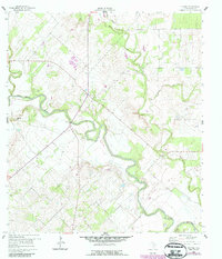
1960 Map of Helena
USGS Topo · Published 1987About this map
Helena stands at the center of this 1960 landscape, a settlement positioned near the significant confluence where the San Antonio River meets its tributaries. The terrain is defined by the winding paths of Ecleto Creek, Cibolo Creek, and McTernan Creek, which carve through the Karnes County countryside. Cultural and historical sites are evident in the presence of the Helena Cem and an additional Cem, providing valuable points of reference for genealogical research in this region of South Texas.
Find a feature on this map
10 named features on this map. Tap any name to fly to it.
Don’t see what you’re looking for? This feature index may not catch every label — zoom into the map to look around manually.
Map Details
Editions of this 1960 Helena Map
Other maps of this area

1920 · Smiley
USGS Topo · 1:125,000

1953 · Beeville
USGS Topo · 1:250,000

1953 · Seguin
USGS Topo · 1:250,000

1956 · Beeville
USGS Topo · 1:250,000

1956 · Karnes City
USGS Topo · 1:62,500

1958 · Seguin
USGS Topo · 1:250,000

1960 · Beeville
USGS Topo · 1:250,000
1960 · Karnes City
USGS Topo · 1:24,000

1960 · Kosciusko
USGS Topo · 1:24,000

1960 · Helena
USGS Topo · 1:24,000