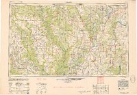
1950 Map of Helena
USGS Topo · Published 1952About this map
The Mississippi River and its massive alluvial plain dominate this mid-century landscape, where a dense network of bayous and meandering channels defines the Arkansas and Mississippi borderlands. Settlement patterns follow the high ground and the paths of major rail lines, including the Chicago Rock Island & Pacific RR and the Missouri Pacific RR. Significant agricultural operations like the Bemis Plantation are visible alongside established river towns such as Des Arc and Cotton Plant.
Find a feature on this map
224 named features on this map. Tap any name to fly to it.
Don’t see what you’re looking for? This feature index may not catch every label — zoom into the map to look around manually.
Map Details
Editions of this 1950 Helena Map
2 editions found

Other maps of this area

1891 · Little Rock
USGS Topo · 1:125,000

1893 · Little Rock
USGS Topo · 1:125,000

1908 · Lula
USGS Topo · 1:24,000
1908 · Dundee
USGS Topo · 1:24,000

1908 · Hollywood
USGS Topo · 1:24,000
1908 · Coahoma
USGS Topo · 1:24,000

1908 · Moon Lake
USGS Topo · 1:24,000
1908 · Jonestown
USGS Topo · 1:24,000

1908 · Walnut Lake
USGS Topo · 1:24,000

1908 · Lake Cormorant
USGS Topo · 1:24,000