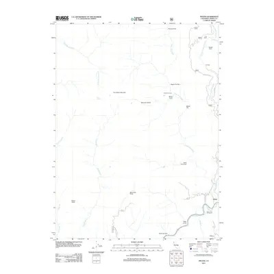
2012 Map of Helena
USGS Topo · Published 2012About this map
The confluence of the Trinity River and the N Fork Trinity River serves as the geographic anchor for this 2012 survey of the Trinity Alps region. Small settlements and former stops like Helena and Coleridge sit tucked along the winding river valleys, while Long Ranch and Waldorf Crossing provide evidence of earlier land use in this isolated terrain. The landscape is defined by its deep drainages and named ridges, including Manzanita Ridge and Treloar Ridge, which rise toward the prominence of Twin Sisters Mountain. Access into this backcountry is primarily via Forest Service roads like Hobo Gulch Rd and Manzanita Ridge Rd. Recreational points such as Pigeon Point Campground highlight the area's modern shift toward river-based activities, while names like Cutthroat Gulch and Squaw Gulch reflect the rugged character of the northern California wilderness.
Find a feature on this map
36 named features on this map. Tap any name to fly to it.
Don’t see what you’re looking for? This feature index may not catch every label — zoom into the map to look around manually.
Map Details
Editions of this 2012 Helena Map
This is the sole edition of this map. No revisions or reprints were ever made.
Other maps of this area

1909 · Big Bar
USGS Topo · 1:96,000

1915 · Big Bar and Vicinity
USGS Topo · 1:250,000

1951 · Hayfork
USGS Topo · 1:62,500

1951 · Helena
USGS Topo · 1:62,500

1951 · Hyampom
USGS Topo · 1:62,500

1951 · Ironside Mountain
USGS Topo · 1:62,500

1958 · Redding
USGS Topo · 1:250,000
1982 · Mt. Hilton
USGS Topo · 1:24,000
1982 · Jim Jam Ridge
USGS Topo · 1:24,000

1982 · Helena
USGS Topo · 1:24,000