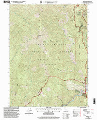
1998 Map of Helena
USGS Topo · Published 2003About this map
Helena serves as the primary settlement on this Trinity County landscape, situated where the Trinity River meets the rugged slopes of the Shasta-Trinity National Forests. The map documents a territory defined by historical extraction and high-altitude wilderness, with mining legacies represented by the Yellowstone Mine and Lone Jack Mine. Significant vertical relief is mapped through landmarks like Twin Sisters Mountain and the towering Backbone Ridge. North of the river, the Trinity Alps Wilderness boundary encloses a dense network of drainages, including French Creek and Baxter Gulch. The presence of Coleridge (Site) and Long Ranch (Site) provides critical evidence of earlier habitation patterns in these mountain canyons, while local infrastructure is anchored by a Post Office, a Gaging Station, and a small Cem near the river bend.
Find a feature on this map
35 named features on this map. Tap any name to fly to it.
Don’t see what you’re looking for? This feature index may not catch every label — zoom into the map to look around manually.
Map Details
Editions of this 1998 Helena Map
This is the sole edition of this map. No revisions or reprints were ever made.
Other maps of this area

1909 · Big Bar
USGS Topo · 1:96,000

1915 · Big Bar and Vicinity
USGS Topo · 1:250,000

1951 · Hayfork
USGS Topo · 1:62,500

1951 · Helena
USGS Topo · 1:62,500

1951 · Hyampom
USGS Topo · 1:62,500

1951 · Ironside Mountain
USGS Topo · 1:62,500

1958 · Redding
USGS Topo · 1:250,000
1982 · Mt. Hilton
USGS Topo · 1:24,000
1982 · Jim Jam Ridge
USGS Topo · 1:24,000

1982 · Helena
USGS Topo · 1:24,000