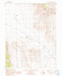
1991 Map of Hell'n Moriah Canyon
USGS Topo · Published 1991About this map
Tule Valley (Depression) dominates this remote Great Basin landscape, situated between the high ridges of the House Range to the east and the Confusion Range to the west. This 1991 provisional survey documents a sparse desert environment where water sources like Jackson Pond and Watsons Cow Pond are critical landmarks. The presence of the Ibex Corral and various Gravel Pits suggests a landscape utilized for seasonal ranching and resource extraction, while a prominent Levee in the valley floor indicates attempts to manage the drainage of this terminal basin.
Find a feature on this map
18 named features on this map. Tap any name to fly to it.
Don’t see what you’re looking for? This feature index may not catch every label — zoom into the map to look around manually.
Map Details
Editions of this 1991 Hell'n Moriah Canyon Map
This is the sole edition of this map. No revisions or reprints were ever made.
Other maps of this area

1908 · Fish Springs
USGS Topo · 1:250,000

1910 · Fish Springs
USGS Topo · 1:250,000

1953 · Richfield
USGS Topo · 1:250,000

1953 · Delta
USGS Topo · 1:250,000

1958 · Richfield
USGS Topo · 1:250,000

1958 · Delta
USGS Topo · 1:250,000

1960 · Notch Peak
USGS Topo · 1:62,500

1960 · Crystal Peak
USGS Topo · 1:62,500

1960 · Conger Mountain
USGS Topo · 1:62,500

1960 · The Barn
USGS Topo · 1:62,500