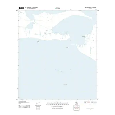
2012 Map of Hell Hole Bayou
USGS Topo · Published 2012About this map
Deadman Island and the surrounding marshlands of Iberia Parish characterize this coastal landscape where the land dissolves into the Gulf of Mexico. The area is defined by its complex hydrology and industrial footprint, notably the Hell Hole Bayou Gas Field and the offshore Lighthouse Point Gas Field. These features highlight the importance of energy extraction in the Louisiana wetlands during the early 21st century. The geography is a mosaic of brackish water bodies like Portage Lake and named coastal landmarks such as Lighthouse Point and Porpoise Point. The presence of Tete Butte Reef just offshore suggests the precarious nature of this subsiding coastline. This survey documents the specific shoreline configuration and maritime industry locations before the continued effects of coastal erosion and tropical weather systems further alter the geography of the Hell Hole region.
Find a feature on this map
11 named features on this map. Tap any name to fly to it.
Don’t see what you’re looking for? This feature index may not catch every label — zoom into the map to look around manually.
Map Details
Editions of this 2012 Hell Hole Bayou Map
This is the sole edition of this map. No revisions or reprints were ever made.
Other maps of this area

1945 · New Orleans
USGS Topo · 1:250,000

1946 · Redfish Point SW
USGS Topo · 1:31,680

1946 · Redfish Point NE
USGS Topo · 1:31,680

1946 · Redfish Point SE
USGS Topo · 1:31,680

1946 · Redfish Point NW
USGS Topo · 1:31,680

1948 · Cypremort Point
USGS Topo · 1:24,000

1949 · Bayou Lucien
USGS Topo · 1:31,680
1951 · Bayou Lucien
USGS Topo · 1:24,000

1951 · Cheniere Au Tigre
USGS Topo · 1:62,500
1954 · Redfish Point SE
USGS Topo · 1:31,680