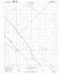
1963 Map of Helm
USGS Topo · Published 1979About this map
The Raisin City Oil Field dominates the northern landscape of this agricultural region, where the grid-like precision of section lines and irrigation roads meets the winding, natural path of the Fresno Slough. Centered on the settlement of Helm, the map illustrates a complex water management system featuring the James Bypass and Fish Slough, essential for the valley's intensive farming. The infrastructure is anchored by the Southern Pacific railroad, which runs parallel to a Landing Strip and serves as a corridor for local commerce. Significant landmarks like the Storage Bin and Gravel Pit appear alongside the prominent Mc Mullin Grade, highlighting the industrial and transport needs of a mid-century California oil and agriculture hub.
Find a feature on this map
34 named features on this map. Tap any name to fly to it.
Don’t see what you’re looking for? This feature index may not catch every label — zoom into the map to look around manually.
Map Details
Editions of this 1963 Helm Map
2 editions found
Other maps of this area

1912 · Coalinga
USGS Topo · 1:125,000

1923 · Kearney Park
USGS Topo · 1:31,680

1924 · Jamesan
USGS Topo · 1:31,680

1925 · Helm
USGS Topo · 1:31,680

1925 · San Joaquin
USGS Topo · 1:31,680

1925 · Raisin
USGS Topo · 1:31,680

1927 · Burrel
USGS Topo · 1:31,680

1931 · Wheatville
USGS Topo · 1:31,680

1931 · Towne Oil Station
USGS Topo · 1:31,680
1946 · Kearney Park
USGS Topo · 1:24,000