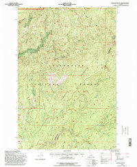
1994 Map of Hemlock Butte
USGS Topo · Published 1998About this map
L E E Ridge and the Clearwater Mountains dominate this 1990s landscape within the Clearwater National Forest. The map documents a rugged wilderness at the border of Clearwater and Idaho counties, defined by an extensive network of drainages and saddles. While primarily unpopulated, the land shows evidence of industrial and administrative use, most notably at the Pistol Grip Mine, the Pioneer Mine, and the Electronic Site and Lookout on the high ground.
Find a feature on this map
29 named features on this map. Tap any name to fly to it.
Don’t see what you’re looking for? This feature index may not catch every label — zoom into the map to look around manually.
Map Details
Editions of this 1994 Hemlock Butte Map
This is the sole edition of this map. No revisions or reprints were ever made.
Other maps of this area

1923 · Washington Creek
USGS Topo · 1:125,000

1924 · Weippe
USGS Topo · 1:125,000

1938 · Headquarters
USGS Topo · 1:48,000

1944 · Headquarters
USGS Topo · 1:62,500

1956 · Hamilton
USGS Topo · 1:250,000

1959 · Hamilton
USGS Topo · 1:250,000

1960 · Hamilton
USGS Topo · 1:250,000

1964 · Hamilton
USGS Topo · 1:250,000
1965 · Larch Butte
USGS Topo · 1:24,000

1965 · French Mountain
USGS Topo · 1:24,000