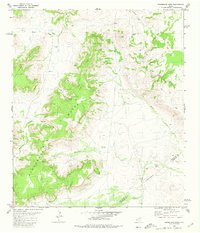
1980 Map of Henderson Mesa
USGS Topo · Published 1980About this map
High desert terrain and massive flat-topped elevations dominate this western Texas landscape at the boundary between Jeff Davis and Brewster Counties. The central mass of Henderson Mesa and the neighboring Arkans Mesa overlook a network of seasonal water sources and canyons, including the winding Horse Thief Creek and the steep Deep Canyon. Evidence of early travel through these heights is marked by several identified routes, such as the Pack Trail and various Jeep Trails that connect remote points like Polks Peak and Jo Peak. This 1980 survey captures a working ranchland environment where water management is critical, as shown by numerous named catchments like Antelope Tank and the tanks near Musquiz Creek. The southern portion of the quadrangle reveals Dutchman Cove, a distinctive landform situated just west of an indefinite boundary line crossing the rocky floor.
Find a feature on this map
24 named features on this map. Tap any name to fly to it.
Don’t see what you’re looking for? This feature index may not catch every label — zoom into the map to look around manually.
Map Details
Editions of this 1980 Henderson Mesa Map
This is the sole edition of this map. No revisions or reprints were ever made.
Other maps of this area

1894 · Fort Davis
USGS Topo · 1:125,000

1895 · Alpine
USGS Topo · 1:125,000

1897 · Fort Davis
USGS Topo · 1:125,000

1954 · Fort Stockton
USGS Topo · 1:250,000

1958 · Fort Stockton
USGS Topo · 1:250,000

1972 · Swayback Mountain
USGS Topo · 1:24,000
1972 · Fort Davis SE
USGS Topo · 1:24,000

1972 · Alpine North
USGS Topo · 1:24,000

1972 · Mitre Peak
USGS Topo · 1:24,000

1972 · Elam Mountain
USGS Topo · 1:24,000