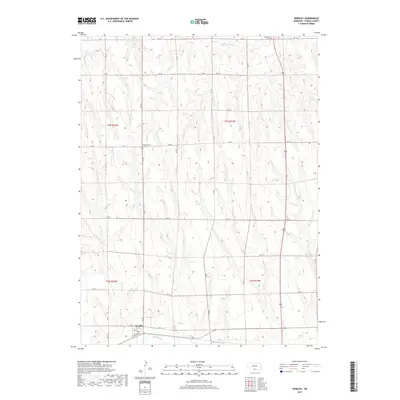
2017 Map of Hendley
USGS Topo · Published 2017About this map
Hendley anchors the southern portion of this Furnas County survey, situated along the valley floor near the winding Beaver Cr. The town's grid is small but distinct, featuring names like N Railway St, 4th St, and 3rd St that hint at its development alongside the corridor. Beyond the immediate settlement, the landscape is defined by a dense network of section-line roads, including RD 711 and RD 719, which navigate the drainage patterns of Crum Cr. For those researching family ties to the area, Garfield Cem and Pleasantview Cem serve as prominent landmarks in the northern and central sections of the quadrangle. The map captures a quintessential Nebraska agricultural landscape where the geometric precision of the township and range system, such as t3n r24w, meets the organic flow of the creek beds.
Find a feature on this map
21 named features on this map. Tap any name to fly to it.
Don’t see what you’re looking for? This feature index may not catch every label — zoom into the map to look around manually.
Map Details
Editions of this 2017 Hendley Map
This is the sole edition of this map. No revisions or reprints were ever made.
Other maps of this area

1896 · Arapahoe
USGS Topo · 1:125,000

1898 · Arapahoe
USGS Topo · 1:125,000

1954 · McCook
USGS Topo · 1:250,000

1955 · Grand Island
USGS Topo · 1:250,000

1957 · McCook
USGS Topo · 1:250,000

1957 · Grand Island
USGS Topo · 1:250,000
1957 · Beaver City SW
USGS Topo · 1:24,000
1957 · Wilsonville
USGS Topo · 1:24,000

1957 · Beaver City SE
USGS Topo · 1:24,000

1958 · McCook
USGS Topo · 1:250,000