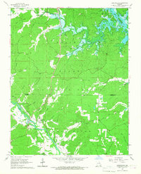
1966 Map of Hendrickson
USGS Topo · Published 1967About this map
Hendrickson and the Missouri Pacific railroad line anchor this mid-1960s landscape, where the Black River and St Francois River converge toward the rising waters of Lake Wappapello. Much of the terrain is defined by the Mark Twain National Forest, characterized by deep-cut drainage patterns like Goldbeck Hollow and Hockinberry Hollow. The map reveals a high density of small family and community burial sites, including Military Crossing Cem and Rucker Cem, which serve as vital markers for genealogical research in this part of Wayne and Butler counties. Industrial activity is noted through scattered mines and a quarry, while local navigation is aided by landmarks like the Flatwoods Lookout Tower and Collins Store. The topography also notes areas of controlled inundation near the lake, illustrating the impact of water management on the local geography.
Find a feature on this map
51 named features on this map. Tap any name to fly to it.
Don’t see what you’re looking for? This feature index may not catch every label — zoom into the map to look around manually.
Map Details
Editions of this 1966 Hendrickson Map
This is the sole edition of this map. No revisions or reprints were ever made.
Other maps of this area

1932 · Piedmont
USGS Topo · 1:62,500

1934 · Greenville
USGS Topo · 1:62,500

1934 · Williamsville
USGS Topo · 1:48,000

1935 · Poplar Bluff
USGS Topo · 1:62,500

1935 · Piedmont
USGS Topo · 1:62,500

1939 · Greenville
USGS Topo · 1:62,500

1939 · Poplar Bluff
USGS Topo · 1:62,500

1940 · Williamsville
USGS Topo · 1:62,500

1949 · Rolla
USGS Topo · 1:250,000

1949 · Poplar Bluff
USGS Topo · 1:62,500