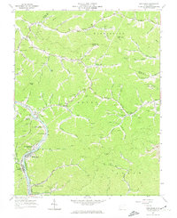
1963 Map of Henlawson
USGS Topo · Published 1974About this map
The Guyandotte River corridor serves as the primary artery for settlement and industry in this 1963 survey of Logan County. Industrial activity is pervasive throughout the hollows, evidenced by a dense network of Gas Wells, Mines, and an extensive Pipeline system. The Chesapeake and Ohio railroad follows the riverbank, connecting coal-rich areas and residential centers like Henlawson, Mitchell Heights, and North Mitchell Heights.
Find a feature on this map
116 named features on this map. Tap any name to fly to it.
Don’t see what you’re looking for? This feature index may not catch every label — zoom into the map to look around manually.
Map Details
Editions of this 1963 Henlawson Map
3 editions found
Other maps of this area

1887 · Warfield
USGS Topo · 1:125,000

1891 · Oceana
USGS Topo · 1:125,000

1891 · Warfield
USGS Topo · 1:125,000

1892 · Huntington
USGS Topo · 1:125,000

1893 · Oceana
USGS Topo · 1:125,000

1898 · Huntington
USGS Topo · 1:125,000

1898 · Oceana
USGS Topo · 1:125,000

1899 · Charleston
USGS Topo · 1:125,000

1902 · Midkiff
USGS Topo · 1:62,500

1907 · Midkiff
USGS Topo · 1:62,500