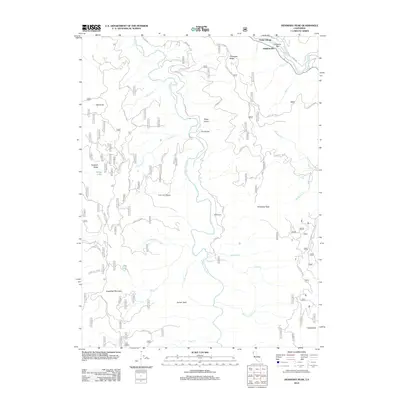
2012 Map of Hennessy Peak
USGS Topo · Published 2012About this map
S Fork Trinity River winds through this mountainous region of Trinity County, serving as the central artery for a landscape defined by high ridges and steep gulches. Small settlements and ranching outposts like Hawkins Bar and Cedar Grove Ranch occupy the more accessible benches near the water, while the high country is dominated by prominent summits including Hennessy Peak and Sugarloaf Mountain. The network of forest routes, such as Forest Rte 6N12 and Hennessey Rd, illustrates the reliance on specialized mountain roads for accessing remote timber and grazing lands. In the northeast corner, Trinity Village sits at the confluence where Icebox Cr meets the main Trinity River flow. Further south, the presence of Todd Ranch and names like Moss Old Mill Rd point to the area's history of small-scale agriculture and early industry tucked into the deep valleys of the Trinity Alps foothills.
Find a feature on this map
46 named features on this map. Tap any name to fly to it.
Don’t see what you’re looking for? This feature index may not catch every label — zoom into the map to look around manually.
Map Details
Editions of this 2012 Hennessy Peak Map
This is the sole edition of this map. No revisions or reprints were ever made.
Other maps of this area

1909 · Big Bar
USGS Topo · 1:96,000

1914 · Pilot Creek
USGS Topo · 1:62,500

1915 · Big Bar and Vicinity
USGS Topo · 1:250,000

1922 · China Flat
USGS Topo · 1:62,500

1951 · Pilot Creek
USGS Topo · 1:62,500

1951 · Hyampom
USGS Topo · 1:62,500

1951 · Ironside Mountain
USGS Topo · 1:62,500

1952 · Willow Creek
USGS Topo · 1:62,500

1958 · Redding
USGS Topo · 1:250,000
1977 · Board Camp Mtn
USGS Topo · 1:24,000