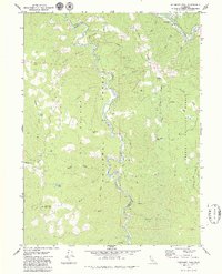
1979 Map of Hennessy Peak
USGS Topo · Published 1979About this map
Hawkins Bar sits at the northern edge of this territory, marking a focal point where human settlement meets the winding course of the Trinity River. The landscape is dominated by the confluence of major waterways and the steep elevations of the Klamath Mountains, where the South Fork Trinity River carves a deep path through the Six Rivers National Forest. Small mountain lakes like Sucker Lake and Big Lake are tucked into the high ridges, alongside prominent summits such as Hennessy Peak and Sugarloaf Mountain.
Find a feature on this map
37 named features on this map. Tap any name to fly to it.
Don’t see what you’re looking for? This feature index may not catch every label — zoom into the map to look around manually.
Map Details
Editions of this 1979 Hennessy Peak Map
2 editions found
Other maps of this area

1909 · Big Bar
USGS Topo · 1:96,000

1914 · Pilot Creek
USGS Topo · 1:62,500

1915 · Big Bar and Vicinity
USGS Topo · 1:250,000

1922 · China Flat
USGS Topo · 1:62,500

1951 · Pilot Creek
USGS Topo · 1:62,500

1951 · Hyampom
USGS Topo · 1:62,500

1951 · Ironside Mountain
USGS Topo · 1:62,500

1952 · Willow Creek
USGS Topo · 1:62,500

1958 · Redding
USGS Topo · 1:250,000
1977 · Board Camp Mtn
USGS Topo · 1:24,000