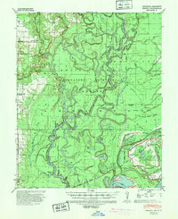
1939 Map of Henrico
USGS Topo · Published 1943About this map
The White River Migratory Waterfowl Refuge dominates this riverine landscape at the junction of Arkansas, Desha, and Phillips counties. The intricately braided channels of the White River and Lagrue Bayou define a region of dense cypress sloughs, including Cypress Lake and Prairie Lake, where meander lines dating back to 1837 and 1847 mark the shifting nature of the delta. Small rural communities like Henrico and Snow Lake are linked by the Missouri Pacific railroad, which runs through the southeastern portion of the quadrangle.
Find a feature on this map
75 named features on this map. Tap any name to fly to it.
Don’t see what you’re looking for? This feature index may not catch every label — zoom into the map to look around manually.
Map Details
Editions of this 1939 Henrico Map
2 editions found
Other maps of this area

1930 · Mellwood
USGS Topo · 1:62,500

1935 · Red Fork
USGS Topo · 1:62,500

1935 · Gillett
USGS Topo · 1:62,500

1939 · Modoc
USGS Topo · 1:62,500

1939 · Indian Bay
USGS Topo · 1:62,500

1939 · Henrico
USGS Topo · 1:62,500

1939 · Pace
USGS Topo · 1:62,500

1939 · Big Island
USGS Topo · 1:62,500

1939 · Mellwood
USGS Topo · 1:62,500

1941 · De Witt
USGS Topo · 1:62,500