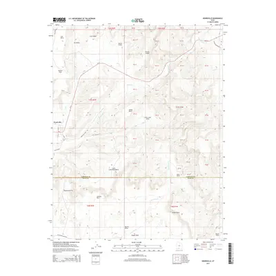
2014 Map of Henrieville
USGS Topo · Published 2014About this map
Henrieville is the primary settlement on this Southern Utah landscape, located at the junction of Ut-12 and the waters of Henrieville Cr. The terrain is defined by a series of prominent plateaus and drainage systems, including Coal Bench to the northwest and the expansive Little Creek Valley in the center. The map documents the complex topography of the region, where numerous canyons like Jimmie Canyon and Pardner Canyon feed into dry washes and creeks. To the south, the landscape transitions across the boundary between Garfield County and Kane County, featuring distinct landmarks such as Chimney Rock and the colorful geologic formations of Kodachrome Flat. This survey highlights the distribution of ranching and natural resources through labels like Middle Bench and Coal Canyon, alongside primitive routes like Cottonwood Canyon Rd.
Find a feature on this map
34 named features on this map. Tap any name to fly to it.
Don’t see what you’re looking for? This feature index may not catch every label — zoom into the map to look around manually.
Map Details
Editions of this 2014 Henrieville Map
This is the sole edition of this map. No revisions or reprints were ever made.
Other maps of this area

1886 · Kanab
USGS Topo · 1:250,000

1886 · Escalante
USGS Topo · 1:250,000

1953 · Cedar City
USGS Topo · 1:250,000

1956 · Escalante
USGS Topo · 1:250,000

1958 · Cedar City
USGS Topo · 1:250,000

1960 · Escalante
USGS Topo · 1:250,000

1962 · Cedar City
USGS Topo · 1:250,000

1964 · Canaan Peak
USGS Topo · 1:24,000

1964 · Henrieville
USGS Topo · 1:24,000
1964 · Pine Lake
USGS Topo · 1:24,000