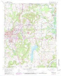
1962 Map of Henryetta
USGS Topo · Published 1979About this map
The industrial and agricultural heart of eastern Oklahoma is visible in this record of the early 1960s, with revisions through the late 1970s. Henryetta serves as the regional hub, showing a dense street grid punctuated by civic landmarks like City Hall and the Hospital. The landscape is shaped by the extraction and manufacturing history of Okmulgee County, evidenced by outlying industrial nodes like Spelter City, Dewar, and the former mining community of Coalton. Transportation networks define the area's development, with the St Louis San Francisco and Missouri Pacific railroads navigating the terrain between Bald Knob and the local watercourses. To the south, the expansion of water resources is marked by Lake Henryetta and the northern reaches of Eufaula Lake. For genealogists, the map preserves the location of rural centers like Salem and the Salem Cem, alongside numerous local schools such as Irving Sch and Webster Sch.
Find a feature on this map
43 named features on this map. Tap any name to fly to it.
Don’t see what you’re looking for? This feature index may not catch every label — zoom into the map to look around manually.
Map Details
Editions of this 1962 Henryetta Map
4 editions found
Other maps of this area

1896 · Okmulgee
USGS Topo · 1:125,000

1900 · Canadian
USGS Topo · 1:125,000

1900 · Wewoka
USGS Topo · 1:125,000

1900 · Okmulgee
USGS Topo · 1:125,000

1901 · Nuyaka
USGS Topo · 1:125,000

1946 · Fort Smith
USGS Topo · 1:250,000

1954 · Oklahoma City
USGS Topo · 1:250,000

1957 · Oklahoma City
USGS Topo · 1:250,000

1962 · Henryetta
USGS Topo · 1:24,000

1962 · Raiford
USGS Topo · 1:24,000