
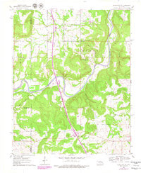
1962 Map of Henryetta SW
USGS Topo · Published 1963About this map
The North Canadian River carves a winding path through this central Oklahoma landscape, defining the rural character of the area in the early 1960s. The map reveals a high concentration of community centers and traditional Creek Nation landmarks, particularly evident in the cluster of institutional buildings around the Yardeka settlement. Here, the Yardeka Ch and Yardeka Sch served as local anchors, while the Hickory Ground No 1 Ch and Hickory Ground No 2 Ch point to established gathering places along the river's northern banks. This topography is shaped by complex drainage systems like Boar Creek and Rattlesnake Hollow, creating a terrain where agriculture and community life followed the contours of the waterways.
Find a feature on this map
26 named features on this map. Tap any name to fly to it.
Don’t see what you’re looking for? This feature index may not catch every label — zoom into the map to look around manually.
Map Details
Editions of this 1962 Henryetta SW Map
2 editions found
Other maps of this area

1900 · Canadian
USGS Topo · 1:125,000

1900 · Wewoka
USGS Topo · 1:125,000

1946 · Fort Smith
USGS Topo · 1:250,000

1954 · Oklahoma City
USGS Topo · 1:250,000

1957 · Oklahoma City
USGS Topo · 1:250,000

1962 · Henryetta
USGS Topo · 1:24,000

1962 · Raiford
USGS Topo · 1:24,000

1962 · Hoffman
USGS Topo · 1:24,000

1963 · Oklahoma City
USGS Topo · 1:250,000

1965 · Fort Smith
USGS Topo · 1:250,000