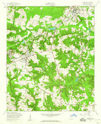
1957 Map of Hephzibah
USGS Topo · Published 1960About this map
The town of Hephzibah and its surrounding agricultural landscape in Richmond County are captured here in the late 1950s, a period of transition as the area's rural character met expanding regional infrastructure. The Georgia and Florida railroad cuts a diagonal path through the terrain, connecting small settlements like Melton and Gracewood to the larger network. Local education and religious life are well-documented through landmarks such as Graham Sch and numerous country churches, including Chalk Mine Mem Ch and Adams Grove Ch.
Find a feature on this map
38 named features on this map. Tap any name to fly to it.
Don’t see what you’re looking for? This feature index may not catch every label — zoom into the map to look around manually.
Map Details
Editions of this 1957 Hephzibah Map
Other maps of this area

1919 · Gough
USGS Topo · 1:62,500

1920 · Greens Cut
USGS Topo · 1:62,500

1921 · Augusta
USGS Topo · 1:62,500

1922 · Hephzibah
USGS Topo · 1:62,500

1943 · Greens Cut
USGS Topo · 1:62,500

1943 · Augusta East
USGS Topo · 1:125,000

1943 · Augusta
USGS Topo · 1:62,500

1948 · Hephzibah
USGS Topo · 1:62,500

1948 · Gough
USGS Topo · 1:62,500

1948 · Blythe
USGS Topo · 1:24,000