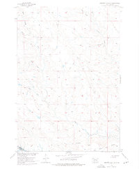
1956 Map of Herbert Creek SE
USGS Topo · Published 1976About this map
Herbert Creek and its complex network of seasonal drainages define this mid-century landscape on the border of Dewey and Stanley counties. Surveyed in the years following the war, the map documents a terrain of expansive open country marked by family-named landmarks like Olson Draw and Talcutt Draw. The southern portion of the sheet is dominated by the Cheyenne R and the distinctive formations of the Gray Buttes, which rise above the surrounding plains. The presence of numerous fence lines across the sections suggests the area's primary use for cattle ranching. The topographical detail, including features like Kid Rich Flats and Beef Draw, provides a clear view of the natural water distribution and land use patterns prior to significant modern development in the Missouri River Basin region.
Find a feature on this map
12 named features on this map. Tap any name to fly to it.
Don’t see what you’re looking for? This feature index may not catch every label — zoom into the map to look around manually.
Map Details
Editions of this 1956 Herbert Creek SE Map
3 editions found
Other maps of this area

1954 · Pierre
USGS Topo · 1:250,000

1956 · Alleman Station
USGS Topo · 1:24,000

1956 · Rousseau Creek SW
USGS Topo · 1:24,000

1956 · Herbert Creek SE
USGS Topo · 1:24,000

1956 · Sansarc NE
USGS Topo · 1:24,000

1956 · Crockett Mountains
USGS Topo · 1:24,000

1958 · Pierre
USGS Topo · 1:250,000

1981 · Herbert Creek
USGS Topo · 1:24,000

1981 · Rousseau Creek NW
USGS Topo · 1:24,000

1981 · Herbert Creek NE
USGS Topo · 1:24,000