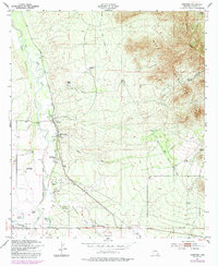
1952 Map of Hereford
USGS Topo · Published 1992About this map
The San Pedro River corridor defines this southern Arizona landscape, flowing north through the San Rafael Del Valle grant toward the Hereford settlement. This mid-century survey illustrates a ranching-heavy economy centered on the river's fertile valley, with numerous named family holdings such as the Dinwiddie Ranch, Double Mill Ranch, and Wick Ranch dotting the basin. To the east, the terrain rises sharply into the Mule Mountains and Escabrosa Ridge, contrasting the alluvial flats where the Hereford Dairy Ranch and Palominas were established.
Find a feature on this map
28 named features on this map. Tap any name to fly to it.
Don’t see what you’re looking for? This feature index may not catch every label — zoom into the map to look around manually.
Map Details
Editions of this 1952 Hereford Map
4 editions found
Other maps of this area

1902 · Bisbee
USGS Topo · 1:62,500

1910 · Bisbee
USGS Topo · 1:62,500

1914 · Hereford
USGS Topo · 1:125,000

1915 · Benson
USGS Topo · 1:125,000

1916 · Pearce
USGS Topo · 1:125,000

1916 · Douglas
USGS Topo · 1:125,000

1919 · Douglas
USGS Topo · 1:125,000

1925 · Gleeson
USGS Topo · 1:62,500

1927 · Bisbee
USGS Topo · 1:62,500

1932 · Stark
USGS Topo · 1:62,500