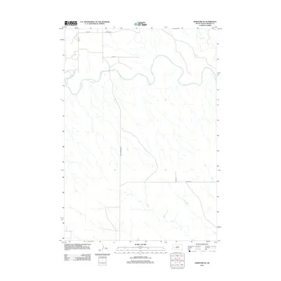
2012 Map of Hereford SE
USGS Topo · Published 2012About this map
The Belle Fourche River meanders across this northern Meade County landscape, defining the local drainage patterns and topography in the early twenty-first century. This rural expanse is characterized by a network of sectional roads and watercourses, including Dry Cr and Elm Cr, which cut through the open plains. The map illustrates a contemporary rural infrastructure where traditional county boundaries meet more modern residential naming conventions, such as Mesquite Pl and 210th Pl. Major transit corridors like New Underwood Rd and Co Hwy Mc-6 provide the primary connectivity through this sparsely populated agricultural and ranching region of western South Dakota.
Find a feature on this map
10 named features on this map. Tap any name to fly to it.
Don’t see what you’re looking for? This feature index may not catch every label — zoom into the map to look around manually.
Map Details
Editions of this 2012 Hereford SE Map
This is the sole edition of this map. No revisions or reprints were ever made.
Other maps of this area

1953 · Viewfield
USGS Topo · 1:24,000

1953 · Hereford SE
USGS Topo · 1:24,000

1953 · Hereford
USGS Topo · 1:24,000

1953 · Hereford SW
USGS Topo · 1:24,000

1953 · Hereford NE
USGS Topo · 1:24,000
1953 · New Underwood NW
USGS Topo · 1:24,000

1953 · Rapid City
USGS Topo · 1:250,000

1954 · Elm Springs SW
USGS Topo · 1:24,000

1954 · Haydraw
USGS Topo · 1:24,000

1957 · Rapid City
USGS Topo · 1:250,000