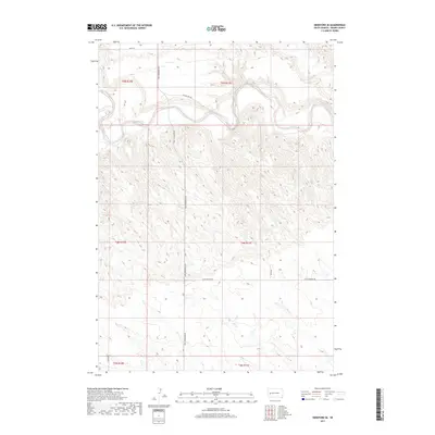
2017 Map of Hereford SE
USGS Topo · Published 2017About this map
The Belle Fourche River winds through the northern portion of this Meade County landscape, defining the local drainage patterns and topography in an area characterized by significant elevation changes. This modern survey illustrates the rural infrastructure of the region, where a network of section-line roads such as New Underwood Rd and 209th St connect isolated ranchlands and seasonal watercourses. Notable minor drainages including Dry Cr and Elm Cr carve through the southern and eastern quadrants, highlighting the watershed's complexity. The arrangement of E River View Rd and W Elm Springs Rd suggests a community oriented around both the river valley and the higher grazing lands, providing a precise spatial record of contemporary South Dakota land use and local geography.
Find a feature on this map
15 named features on this map. Tap any name to fly to it.
Don’t see what you’re looking for? This feature index may not catch every label — zoom into the map to look around manually.
Map Details
Editions of this 2017 Hereford SE Map
This is the sole edition of this map. No revisions or reprints were ever made.
Other maps of this area

1953 · Viewfield
USGS Topo · 1:24,000

1953 · Hereford SE
USGS Topo · 1:24,000

1953 · Hereford
USGS Topo · 1:24,000

1953 · Hereford SW
USGS Topo · 1:24,000

1953 · Hereford NE
USGS Topo · 1:24,000
1953 · New Underwood NW
USGS Topo · 1:24,000

1953 · Rapid City
USGS Topo · 1:250,000

1954 · Elm Springs SW
USGS Topo · 1:24,000

1954 · Haydraw
USGS Topo · 1:24,000

1957 · Rapid City
USGS Topo · 1:250,000