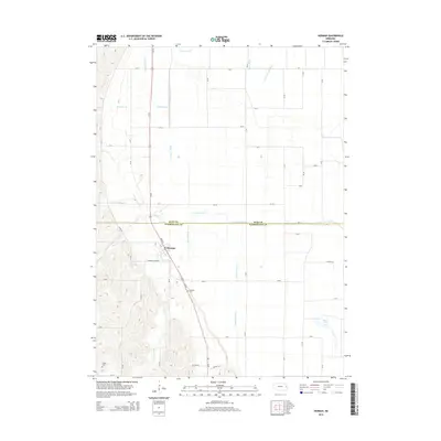
2014 Map of Herman
USGS Topo · Published 2014About this map
The village of Herman stands at the center of this agricultural corridor in eastern Nebraska, situated along the Burt Co Washington Co line. The landscape is defined by an extensive network of drainage infrastructure, such as the Cameron Ditch, Greenleaf Ditch, and Harney Slough Ditch, which manage the low-lying terrain between the hills and the Missouri River floodplain. Natural waterways like New York Cr and Crannell Cr wind through the area, while the eastern portion of the map is punctuated by Burns Lake. Genealogists will find the Herman Cem and Thone Cem clearly marked, alongside the local landmark of Herman School Rd, which anchors the small community. The intersection of local county roads and irrigation channels illustrates a region deeply shaped by drainage engineering and small-town Nebraska life.
Find a feature on this map
51 named features on this map. Tap any name to fly to it.
Don’t see what you’re looking for? This feature index may not catch every label — zoom into the map to look around manually.
Map Details
Editions of this 2014 Herman Map
This is the sole edition of this map. No revisions or reprints were ever made.
Other maps of this area

1955 · Fremont
USGS Topo · 1:250,000

1957 · Fremont
USGS Topo · 1:250,000

1958 · Fremont
USGS Topo · 1:250,000
1969 · Orum
USGS Topo · 1:24,000

1970 · Oakland SE
USGS Topo · 1:24,000

1970 · Little Sioux
USGS Topo · 1:24,000

1970 · Herman
USGS Topo · 1:24,000

1970 · Mondamin
USGS Topo · 1:24,000
1970 · Modale
USGS Topo · 1:24,000
1970 · Nickerson NE
USGS Topo · 1:24,000