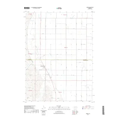
2017 Map of Herman
USGS Topo · Published 2017About this map
The village of Herman stands at the heart of this landscape along the border of Burt and Washington counties, surrounded by a complex network of agricultural waterways. The drainage system here is particularly dense, featuring the engineered County Line Ditch, Cameron Ditch, and Fish Cr Ditch, which work in tandem with natural flows like New York Cr and Whittier Cr. This intersection of natural hydrology and human-managed irrigation reflects the intensive agricultural heritage of eastern Nebraska. For those tracing local family history, the map identifies significant sites such as the Herman Cem just south of the village and the Thone Cem to the southwest, while Herman School Rd points toward the community's early social infrastructure. Further east, the terrain levels out near Burns Lake, showing the transition toward the Missouri River floodplain.
Find a feature on this map
60 named features on this map. Tap any name to fly to it.
Don’t see what you’re looking for? This feature index may not catch every label — zoom into the map to look around manually.
Map Details
Editions of this 2017 Herman Map
This is the sole edition of this map. No revisions or reprints were ever made.
Other maps of this area

1955 · Fremont
USGS Topo · 1:250,000

1957 · Fremont
USGS Topo · 1:250,000

1958 · Fremont
USGS Topo · 1:250,000
1969 · Orum
USGS Topo · 1:24,000

1970 · Oakland SE
USGS Topo · 1:24,000

1970 · Little Sioux
USGS Topo · 1:24,000

1970 · Herman
USGS Topo · 1:24,000

1970 · Mondamin
USGS Topo · 1:24,000
1970 · Modale
USGS Topo · 1:24,000
1970 · Nickerson NE
USGS Topo · 1:24,000