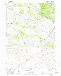
1950 Map of Herman Ranch
USGS Topo · Published 1978About this map
Emigrant Trail tracks cut across this landscape, following the course of Cottonwood Creek as it winds toward the North Platte River. This 1950 field-checked survey reveals a mid-century ranching environment where historical overland routes remain prominent, marked by a physical Oregon Trail Marker and isolated burials such as the lone Grave near Herman Ranch and a cluster of Graves further east.
Find a feature on this map
19 named features on this map. Tap any name to fly to it.
Don’t see what you’re looking for? This feature index may not catch every label — zoom into the map to look around manually.
Map Details
Editions of this 1950 Herman Ranch Map
3 editions found
Other maps of this area

1896 · Hartville
USGS Topo · 1:125,000

1901 · Hartville
USGS Topo · 1:125,000

1950 · Coleman Butte
USGS Topo · 1:24,000

1950 · Herman Ranch
USGS Topo · 1:24,000

1950 · Haushar Ranch
USGS Topo · 1:24,000

1950 · Guernsey Reservoir
USGS Topo · 1:24,000

1951 · Coleman Butte
USGS Topo · 1:24,000

1951 · Sibley Peak
USGS Topo · 1:24,000

1951 · Haushar Ranch
USGS Topo · 1:24,000

1951 · Guernsey Reservoir
USGS Topo · 1:24,000