
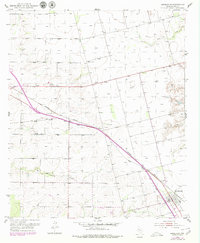
1952 Map of Hermleigh
USGS Topo · Published 1953About this map
The town of Hermleigh serves as the focal point for this early 1950s survey of southeastern Scurry County, where the convergence of two major transportation lines dictated the local geography. The Roscoe Snyder and Pacific and the Panhandle and Santa Fe Pacific railroads cross paths here, illustrating the area's importance as a regional transit and shipping hub for West Texas cattle and cotton during this era.
Find a feature on this map
11 named features on this map. Tap any name to fly to it.
Don’t see what you’re looking for? This feature index may not catch every label — zoom into the map to look around manually.
Map Details
Editions of this 1952 Hermleigh Map
2 editions found
Other maps of this area

1932 · Camp Springs
USGS Topo · 1:62,500

1951 · Dunn
USGS Topo · 1:24,000

1952 · Snyder
USGS Topo · 1:24,000

1952 · China Grove
USGS Topo · 1:24,000

1954 · Lloyd Mountain
USGS Topo · 1:24,000

1954 · Brand
USGS Topo · 1:24,000

1954 · Big Spring
USGS Topo · 1:250,000

1958 · Big Spring
USGS Topo · 1:250,000

1969 · Camp Springs
USGS Topo · 1:24,000

1969 · Inadale NW
USGS Topo · 1:24,000