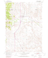
1953 Map of Hermosa
USGS Topo · Published 1980About this map
Hermosa sits at the junction of rail and water in the mid-20th century, serving as a primary point of interest along the Chicago and North Western railroad line. The settlement's proximity to Battle Creek and the nearby reservoir highlights the importance of water management in this semi-arid South Dakota landscape. Local history and genealogy are anchored by the Cem and various Windmill sites that dot the surrounding ranch land.
Find a feature on this map
12 named features on this map. Tap any name to fly to it.
Don’t see what you’re looking for? This feature index may not catch every label — zoom into the map to look around manually.
Map Details
Editions of this 1953 Hermosa Map
3 editions found
Other maps of this area

1894 · Hermosa
USGS Topo · 1:125,000

1901 · Hermosa
USGS Topo · 1:125,000

1953 · Hermosa NW
USGS Topo · 1:24,000

1953 · Hermosa
USGS Topo · 1:24,000

1953 · Hermosa SE
USGS Topo · 1:24,000
1953 · Hermosa NE
USGS Topo · 1:24,000
1954 · Rockerville
USGS Topo · 1:24,000

1954 · Hayward
USGS Topo · 1:24,000

1954 · Mount Rushmore
USGS Topo · 1:62,500

1955 · Hot Springs
USGS Topo · 1:250,000