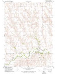
1978 Map of Herndon
USGS Topo · Published 1979About this map
Herndon serves as the central hub of this Northwest Kansas landscape, situated where the Burlington rail line follows the winding course of Beaver Creek. The map documents a rural community deeply tied to its geography and history, featuring a cluster of local landmarks like the Water Tank, Sewage Disposal Ponds, and several industrial sites including Quarries and a Sandpit. The survey reveals the intersection of Richland and Elk townships just south of the Nebraska-Kansas state line. Genealogists will find particular value in the placement of several burial grounds, including Union Cem, St Marys Cem, and Evangelical Cem, which reflect the area's diverse religious heritage. The presence of a Pumping Station and an extensive Pipeline network indicates the importance of resource management in these high plains, while various Fords across the creek show the persistence of traditional river crossings.
Find a feature on this map
24 named features on this map. Tap any name to fly to it.
Don’t see what you’re looking for? This feature index may not catch every label — zoom into the map to look around manually.
Map Details
Editions of this 1978 Herndon Map
This is the sole edition of this map. No revisions or reprints were ever made.
Other maps of this area

1951 · Herndon
USGS Topo · 1:62,500

1951 · Oberlin
USGS Topo · 1:62,500

1954 · McCook
USGS Topo · 1:250,000

1954 · Goodland
USGS Topo · 1:250,000

1956 · Goodland
USGS Topo · 1:250,000

1957 · McCook
USGS Topo · 1:250,000

1957 · Goodland
USGS Topo · 1:250,000

1957 · McCook SW
USGS Topo · 1:24,000

1958 · McCook
USGS Topo · 1:250,000

1962 · Culbertson SW
USGS Topo · 1:24,000