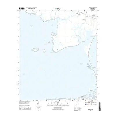
2014 Map of Heron Bay
USGS Topo · Published 2014About this map
Dauphin Island and the surrounding coastal waters of Mobile Bay and the Mississippi Sound anchor this coastal survey. The landscape is defined by the narrow passage of the Intracoastal Waterway and the engineering of the Dauphin Island Bridge, which connects the barrier island to the mainland at Cedar Point. To the north, the community of Heron Bay is positioned near the Dorlan Community Cem, while the tidal marshes are broken by numerous named points and islands, such as Murder Point and Turtleback Island. The intricate network of tidal channels including Pass aux Herons and Grants Pass illustrates the historical maritime navigation routes required to transit between the bays. On the island's eastern end, the settlement of Island Shores sits adjacent to the Dauphin Island Airport, showing the modern development of this long-established fishing and recreational area.
Find a feature on this map
65 named features on this map. Tap any name to fly to it.
Don’t see what you’re looking for? This feature index may not catch every label — zoom into the map to look around manually.
Map Details
Editions of this 2014 Heron Bay Map
This is the sole edition of this map. No revisions or reprints were ever made.
Other maps of this area

1921 · Grand Bay
USGS Topo · 1:62,500

1921 · Petit Bois Island
USGS Topo · 1:62,500

1921 · Dauphin Island
USGS Topo · 1:62,500

1921 · Delchamps
USGS Topo · 1:62,500

1941 · Cedar Point
USGS Topo · 1:62,500

1942 · Petit Bois Island
USGS Topo · 1:62,500

1942 · Fort Morgan
USGS Topo · 1:62,500

1943 · Cedar Point
USGS Topo · 1:62,500

1943 · Grand Bay
USGS Topo · 1:62,500

1953 · Mobile
USGS Topo · 1:250,000