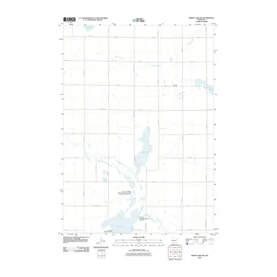
2010 Map of Heron Lake NW
USGS Topo · Published 2010About this map
The Des Moines River winds through the southwestern corner of Murray County, anchoring a landscape of glacial lakes and managed wetlands. This 2010 survey illustrates the hydrological importance of the region, featuring Talcot Lake and Oaks Lake as central aquatic landmarks. The drainage network is further defined by Highwater Creek in the north and the smaller Lake Louisa and Long Lake near the eastern boundary. The presence of the Talcot Lake Wildlife Area Dam and the Talcot Lake Wildlife Management Area Dam highlights modern efforts to regulate these waters for habitat preservation.
Find a feature on this map
39 named features on this map. Tap any name to fly to it.
Don’t see what you’re looking for? This feature index may not catch every label — zoom into the map to look around manually.
Map Details
Editions of this 2010 Heron Lake NW Map
This is the sole edition of this map. No revisions or reprints were ever made.
Other maps of this area

1953 · New Ulm
USGS Topo · 1:250,000

1954 · Fairmont
USGS Topo · 1:250,000

1957 · New Ulm
USGS Topo · 1:250,000

1958 · New Ulm
USGS Topo · 1:250,000

1958 · Fairmont
USGS Topo · 1:250,000

1967 · New Ulm
USGS Topo · 1:250,000

1967 · Storden
USGS Topo · 1:24,000

1967 · Dovray
USGS Topo · 1:24,000
1967 · Westbrook
USGS Topo · 1:24,000

1970 · Heron Lake NW
USGS Topo · 1:24,000