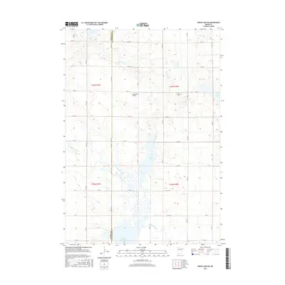
2016 Map of Heron Lake NW
USGS Topo · Published 2016About this map
Coteau des Prairies, a vast highland stretching across the southwestern plains of Minnesota, defines the geography of this 2016 survey along the Murray and Cottonwood county line. The landscape is characterized by a series of glacial lakes and wetlands, most notably Oaks Lake and the expansive Wildlife Impoundment to the south. The headwaters of the Des Moines River wind through the prairie, flanked by a grid of rural roads such as Co Rd 7 and 330th Ave. Historic local landmarks like Emanuel Cem provide points of reference for genealogists within these agricultural townships. This map captures the region's intricate water network, from the smaller Lake Louisa and Long Lake to the drainage of Highwater Cr, showing the persistent influence of the glacial terrain on modern land use and conservation.
Find a feature on this map
42 named features on this map. Tap any name to fly to it.
Don’t see what you’re looking for? This feature index may not catch every label — zoom into the map to look around manually.
Map Details
Editions of this 2016 Heron Lake NW Map
This is the sole edition of this map. No revisions or reprints were ever made.
Other maps of this area

1953 · New Ulm
USGS Topo · 1:250,000

1954 · Fairmont
USGS Topo · 1:250,000

1957 · New Ulm
USGS Topo · 1:250,000

1958 · New Ulm
USGS Topo · 1:250,000

1958 · Fairmont
USGS Topo · 1:250,000

1967 · New Ulm
USGS Topo · 1:250,000

1967 · Storden
USGS Topo · 1:24,000

1967 · Dovray
USGS Topo · 1:24,000
1967 · Westbrook
USGS Topo · 1:24,000

1970 · Heron Lake NW
USGS Topo · 1:24,000