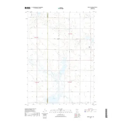
2019 Map of Heron Lake NW
USGS Topo · Published 2019About this map
The Coteau des Prairies plateau dictates the drainage of this prairie landscape along the border of Murray and Cottonwood Counties. The headwaters of the Des Moines River wind through the southern sections of the quadrangle, feeding into a significant Wildlife Impoundment and passing near the wetland margins of Oaks Lake. The map reveals a highly structured agricultural grid, where section lines are traced by an extensive network of rural roads like 330th Ave and 380th St. Local history markers are preserved in the placement of the Emanuel Cem and the Rolling Hills Airport, providing specific coordinates for genealogical research and land-use studies. The terrain is defined by its glacial heritage, alternating between high ground and water-filled depressions like Lake Louisa and Long Lake that characterize this region of southwest Minnesota.
Find a feature on this map
43 named features on this map. Tap any name to fly to it.
Don’t see what you’re looking for? This feature index may not catch every label — zoom into the map to look around manually.
Map Details
Editions of this 2019 Heron Lake NW Map
This is the sole edition of this map. No revisions or reprints were ever made.
Other maps of this area

1953 · New Ulm
USGS Topo · 1:250,000

1954 · Fairmont
USGS Topo · 1:250,000

1957 · New Ulm
USGS Topo · 1:250,000

1958 · New Ulm
USGS Topo · 1:250,000

1958 · Fairmont
USGS Topo · 1:250,000

1967 · New Ulm
USGS Topo · 1:250,000

1967 · Storden
USGS Topo · 1:24,000

1967 · Dovray
USGS Topo · 1:24,000
1967 · Westbrook
USGS Topo · 1:24,000

1970 · Heron Lake NW
USGS Topo · 1:24,000