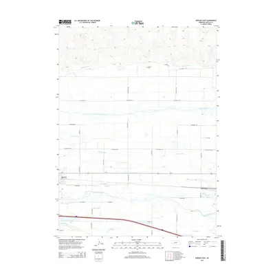
2014 Map of Hershey East
USGS Topo · Published 2014About this map
The North Platte River and South Platte River converge toward the east in this portion of Lincoln County, defining a landscape dominated by a complex network of Nebraska's historic irrigation systems. The community of Hershey sits at the intersection of Us-30 and N Parkway Rd, positioned between the river channels and the railroad corridor. This 2014 survey documents the continued reliance on water management infrastructure, including the Birdwood Canal, Suburban Canal, and N Platte Canal, which crisscross the flat valley floor to support local agriculture. North of the river, the terrain rises into the Sandhills, where family-named landmarks like McNeel Cem and rural routes such as N Game Trail Rd provide anchor points for local genealogists. In the southern wetlands, the distinct drainages of Beer Slough and Fremont Slough weave through the Platte Valley alongside the settlement at Birdwood.
Find a feature on this map
36 named features on this map. Tap any name to fly to it.
Don’t see what you’re looking for? This feature index may not catch every label — zoom into the map to look around manually.
Map Details
Editions of this 2014 Hershey East Map
This is the sole edition of this map. No revisions or reprints were ever made.
Other maps of this area

1898 · Paxton
USGS Topo · 1:125,000

1899 · North Platte
USGS Topo · 1:125,000

1901 · Paxton
USGS Topo · 1:125,000

1902 · North Platte
USGS Topo · 1:125,000

1954 · North Platte
USGS Topo · 1:250,000

1956 · North Platte
USGS Topo · 1:250,000

1957 · North Platte
USGS Topo · 1:250,000

1967 · North Platte
USGS Topo · 1:250,000

1970 · North Platte West
USGS Topo · 1:24,000
1970 · North Platte SW
USGS Topo · 1:24,000